The climate crisis is a humanitarian crisis. Every year, climate-induced disasters are responsible for killing 67,000 people and driving 26 million into poverty. The world’s most exposed people suffer the most, with older people, women and girls, and people living with disabilities being disproportionately affected. The International Federation of Red Cross and Red Crescent Societies (IFRC) and its network of 191 National Red Cross and Red Crescent Societies work closely with communities exposed to climate-related hazards by significantly increasing disaster risk reduction efforts, anticipating extreme weather events ahead of their impact, and pursuing nature-based solutions. Through working with nature, the Red Cross Red Crescent Movement aims to protect the environment and save lives. 510, the data and digital initiative of the Netherlands Red Cross, supports these efforts by working on projects pertaining to landscape restoration and mitigating risks posed by water-related hazards.
Using data to build resilience against water-related risks
Climate change is primarily a water crisis. It has affected the water cycle in various ways, leading to plenty of water hazards increasing in frequency, and negatively impacting millions of people and their livelihoods globally. In many parts of the world, scarce and continuously declining availabilities of water cause major concerns, such as wildfires or droughts leading to agricultural shortages. Meanwhile, in other places, too much water causes great disturbance in the form of floods, landslides, and sinkholes. Together with the Water, Advisory and Innovation unit within the Netherlands Red Cross and other National Societies, 510 analyzes different water-related data to better understand climate events, and use it as guidance to reduce their impact on people’s lives. Data about water not only relates to mitigating droughts and flooding, but also includes WASH-related activities, such as building safe water sources and latrines, or hygiene promotion. Examples of data gathered for this purpose include the identification of locations of water pumps, mappings of water-critical infrastructures, as well as designs of urban WASH and drainage systems.
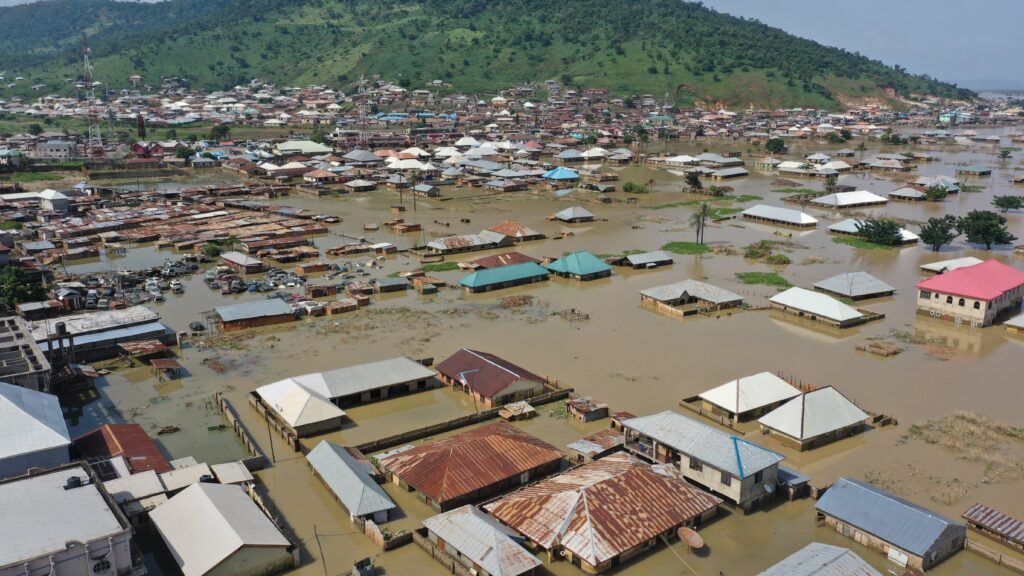
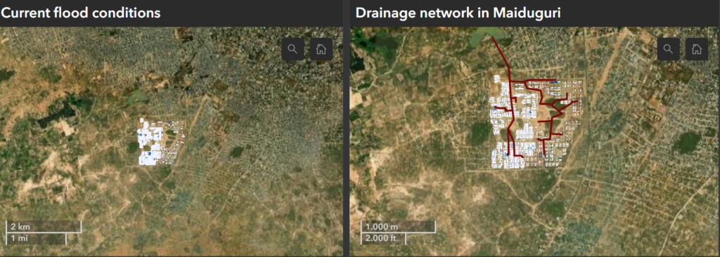
An example of utilizing data to improve water systems is a flood modelling tool which is used to support water security in camps hosting internally displaced persons in North-Eastern Nigeria. The approximately 700 settlements, home to nearly 3 million people, are exposed to frequent flooding which significantly increases water insecurity in the region. To reduce this risk and mitigate the consequences of flooding in and around the camps, 510 has been partnering with the Dutch Surge Support (DSS water) program implemented by the Netherlands Enterprise Agency, the International Organization for Migration (IOM) and Deltares to design effective drainage systems for selected priority camps. Such tools can provide critical information to reduce water insecurities in a timely, effective and sustainable manner. Following a participatory approach, the flood model can estimate the extent and quantity of flooding events in the camps, and verify results with locally available data. A dashboard on the Deltares website visualizes these results in an easy-to-digest manner, indicating which camps are most frequently and severely flooded which allows for conclusions on actions to be prioritized and which interventions are most suitable considering the local setting. The information is also used to design emergency plans and optimize maintenance in existing camps, as well as to support the site selection of future camps.
“Led by DSS Water, IOM, Deltares and 510 have come together to work on our shared goal of promoting inclusive resilience when dealing with water-related risks. By pooling their expertise, these organizations offer a holistic approach to providing extensive technical assistance in addressing water and climate risks that affect refugee and internally displaced populations in North-Eastern Nigeria.”
Aklilu Teklesadik, Hazard and Impact Analyst at 510
Combatting land degradation for a more sustainable future
Landscapes are ever-changing: cities and urban spaces are built and expanded, forests burn down or give way to more profitable land use such as mining, rivers flow over or dry up, and fields used for agriculture become barren as an effect of drought. As such, land degradation has an immense influence not only on the environmental state of the region, but plays a role in its socio-economic wellbeing as well. As these processes are interlinked and impact each other immensely, landscape restoration efforts have the potential to yield a healthier nature, as well as socio-economic opportunities. This is why a holistic approach to land degradation which takes into account a variety of aspects is essential in restoring landscapes, as well as monitoring changes in their composition. Following this approach, 510 developed the Landscape Restoration Tool which includes a Historical Analysis comparing satellite images of a region from two (or more) moments in time. The tool maps out which regions have been affected by deforestation, allowing for an identification of zones that should be prioritized, as well as zones where the reforestation success rate may be higher, thus guiding the selection of areas to be reforested first.
An example of landscape restoration is the Green Pearls project in Haiti, a country in the Caribbean which is prone to frequent earthquakes, hurricanes and floods. On top of this, Haiti has also been negatively affected by deforestation, further taking down barriers protecting it from disasters. Since 2019, the Haiti Red Cross Society and the Netherlands Red Cross under the Princess Margriet Fund have been working to restore Haiti’s reputation as the ‘Green Pearl’ of the Caribbean by creating many smaller green pearls – communities which balance human needs with natural resources and economic development. Green pearls consist of three zones: one for reforestation activities, one for regenerative and sustainable farming, and an economic zone where people live and work. 510’s Landscape Restoration Tool played an important role in this project by providing a scan of satellite images showcasing deforestation hotspots to create an overview of the most affected areas which are the most suitable for undergoing restoration.
“The scale of deforestation in Haiti is huge. In theory, almost half of the land should be reforested. In practice, recovery happens in small areas. But how do you choose those areas? And even within those areas, how do you know where to start and which parts need to be reforested first? That’s where a site’s suitability analysis can help.”
Angelina Savchuk, GIS and Remote Sensing Analyst at 510
Over the next two decades, the two National Societies aim to establish a total of 30 green pearls in Haiti.